


TBPLIVE
คำอธิบายของTBPLIVE
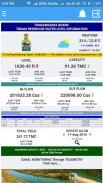
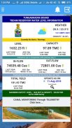
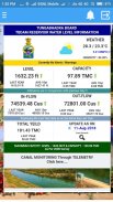
Welcome to the Tungabhadra Board, Reservoir Storage Management System Portal. The River Tungabhadra derives its name from two streams viz., the Tunga,
about 147 km(91.6 miles) long and the Bhadra, about 178 Km (110.9 miles) long which rise in the Western Ghats. The river after the influence of the two streams near Shimoga,
runs for about 531 Km(330 miles) till it joins the river Krishna at Sangamaleshwaram in Andhra Pradesh. It runs for 382 Km (237 miles) in Karnataka, forms the boundary between
Karnataka and Andhra Pradesh for58 Km (36 miles) and further runs for the next 91 Km (57 miles) in Andhra Pradesh. The total catchment area of the river is 69,552 Sq Km
(26,856 Sq miles) up to its confluence with Krishnaand it is 28,177 Sq Km (10,880 Sq miles) up to Tungabhadra Dam. It is influenced chiefly by the South-West monsoon. It is a
perennial river but the summer flows dwindle to as low as 2.83 to1.42 cumec (100 to 50 cusec).
ยินดีต้อนรับสู่คณะกรรมการ Tungabhadra, พอร์ทัลระบบจัดการคลังสินค้าคลังสินค้า แม่น้ำ Tungabhadra มาจากชื่อของทั้งสองลำธาร ได้แก่ Tunga,
ประมาณ 147 กม. (91.6 ไมล์) และ Bhadra ยาวประมาณ 178 กิโลเมตร (110.9 ไมล์) ซึ่งเพิ่มขึ้นใน Western Ghats แม่น้ำหลังจากอิทธิพลของทั้งสองลำธารใกล้ Shimoga,
วิ่งประมาณ 531 กิโลเมตร (330 ไมล์) จนกว่าจะเข้าร่วมกับแม่น้ำ Krishna ที่ Sangamaleshwaram ในรัฐอานธรประเทศ มีพื้นที่ 382 กม. (237 ไมล์) ใน Karnataka สร้างเขตแดนระหว่าง
Karnataka และ Andhra Pradesh เป็นเวลา 58 กม. (36 ไมล์) และวิ่งต่อไปอีก 91 กม. (57 ไมล์) ในรัฐอานธรประเทศ พื้นที่เก็บกักน้ำรวมของแม่น้ำคือ 69,552 ตารางกิโลเมตร
(26,856 ตร.ม. ) จนถึงจุดบรรจบกับ Krishnaand มีเนื้อที่ 28,177 ตารางกิโลเมตร (10,880 ตร.ม. ) ถึงเขื่อน Tungabhadra ส่วนใหญ่เป็นอิทธิพลจากมรสุมตะวันตกเฉียงใต้ มันคือ
แม่น้ำยืนต้น แต่ช่วงฤดูร้อนลดลงเหลือ 2.83 ถึง 1.42 cumec (100 ถึง 50 cusec)
TBPLIVE--เวอร์ชั่น9.2
(26-03-2021)TBPLIVE - ข้อมูล APK
เวอร์ชั่น APK: 9.2แพ็คเกจ: tbapp.apzxnเวอร์ชั่นล่าสุดของTBPLIVE


 3.64
3.64


แอปในประเภทเดียวกัน

คุณอาจจะชอบ...


